Showing posts with label Greenside Inn Maybole. Show all posts

Friday, 12 August 2022

Kirkoswald to Maybole

Alan McQ, Davie C, Davie McM, Dougie, Francesco, Hugh, Rex, Robert

It was a bright, sunny day in the ancient capital of Carrick as a band of Ooters met for a coffee before getting the bus to Kirkoswald. However, it would seem that not all Ooters read this blog as only Alan McQ and Dougie went to the Carrick Centre as had been intimated whilst some of the others (well, let's just say the three from Kilmarnock) had their coffee at the Dairy Corner Tea Room on the High Street - probably because it was marginally closer to their car than the Carrick Centre and who can blame them for not wanting to walk further than necessary? At 10am, the five coffee drinkers met up at the Greenside with the others: a dug-less Derval Davie and Rex who had brought his Italian son-in-law Francesco along for the outing.

The bus for Kirkoswald was a few minutes late in arriving and the driver wasted no time in getting back on schedule as we hurtled along the country roads at such a breakneck speed that some of us wondered whether there was a bomb strapped to the vehicle. It was therefore with a sense of relief that we disembarked in Kirkoswald and started to make our way back to Maybole on foot. Our route out of the village followed the Kirkbrae up past the local church and the newer cemetery then down a shaded lane and across the Milton Burn before a long section which was quite overgrown in places but today's leader had been in the Scouts and came prepared with a pair of secateurs to cut back any obstructive undergrowth.

About a mile into the walk, we reached a quiet back road and followed this for the next couple of miles past Chapelbarr Cottage and up to the highest point of the day's walk near the ruins of High Newlands where we stopped for coffee and enjoyed the views and banter. We left the tarmac here and continued along a track through the long grass, noting that there was no longer any livestock grazing up here on the high moorland and tree planting was underway. Our route continued past the Drummochreen Cairn which marks the spot where, in 1599, Andrew MacAlexander of Drummochreen was murdered by Hew Kennedy of Girvan Mains. 


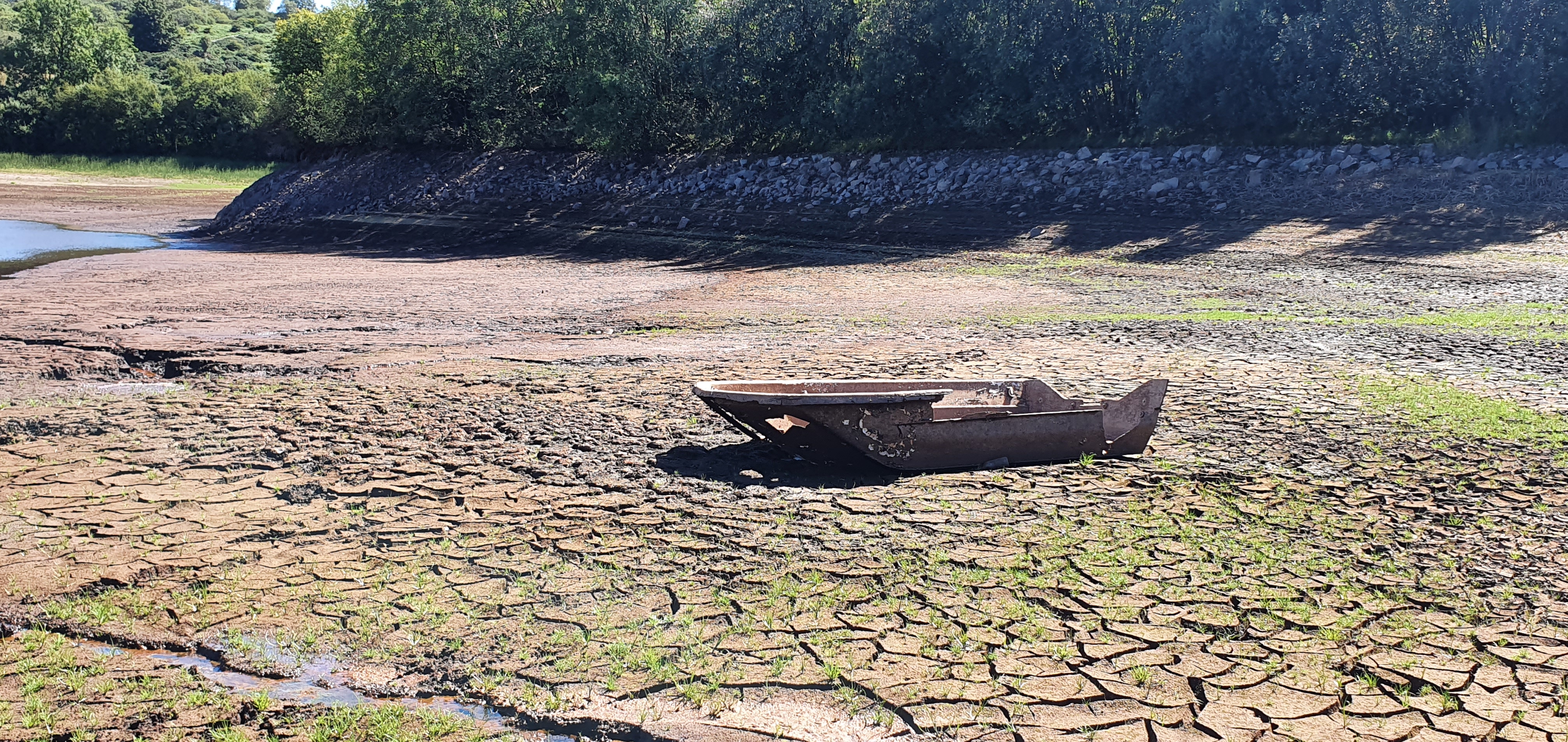
We maintained a good pace as we followed the track down the intriguingly named Ghaist Glen to our planned lunch stop in the shade of the trees beside Loch Spouts which had been visited by some of us last summer. However, the water level of the loch was very much lower on this occasion; exposing the wrecks of various boats. It was not apparent whether the low volume of water in the reservoir had been due to repair works being carried out or a prolonged period of below-average rainfall. There was once a crannog on the loch and medieval artefacts have been discovered in this area. Loch Spouts became Maybole's main water supply in the 1880s but has since been replaced by Loch Bradan. 


After lunch we resumed our march back to Maybole by following the tarmac road round the base of Kildoon (none of us expressed any interest in climbing the hill on this occasion). Alan McQ showed Rex and Francesco the waterfalls on the Capenoch Burn whilst the others were more interested in getting back to the town for a refreshment.


The total distance for the day was 8.2 miles which we covered in around 3.5 hours (including two stops). We spent a very enjoyable hour in the beer garden of the Greenside before making our way home.

Friday, 8 July 2022

Images of the walk between Minishant and Maybole featuring Alan McQ, Allan, Davie C, Dougie, Jimmy and Rex

Colourful display of wild flowers at Minishant

Here come the Ooters! 

It was quiet country roads all the way.

On the Gardenrose bridge which crosses the Maybole bypass. Mochrum Hill shrouded in mist.

Beer and pizza at the Greenside


Thursday, 16 February 2017

Maidens to Maybole via Mochrum Hill 15 February


Alan McQ, Alan, Allan, Davie Mc, Dougie, Gus, Jim, Jimmy, Johnny, Kenny T, Malcolm, Robert

We met at the Green in Maybole in order to get the bus to Maidens to start our walk. Despite words of caution from the locals, the bus arrived on time and off we went on a tour of rural Carrick before we alighted on a dry morning, but with a chill wind blowing. Alan McQ, (teachers get far too many holidays these days), was using his local knowledge to lead us on a walk which was to take us over Mochrum Hill (270m, 886ft) and back to our starting point. Our friend Ian Hill had taken us up Mochrum Hill before, but for many this was to be a new excursion.
Following the road adjacent to the beach, we made our way up the track and then followed the old railway line until we emerged at the Cat Gates into Culzean. From there we followed Alan as he took us on towards the road just north of the Swan Pond and up to the Walled Garden, where we could see substantial works in progress. Coffee was called for at the picnic benches.
The next stop was at the memorial to the Kennedys, a feature that had gone unnoticed to us in the past. Leaving Culzean at the main entrance point, taking note of new landscaping , we crossed the A719 and took the track which relentlessly took us up towards the hill. When the track ran out, the going got trickier over tufts and the like, and we were grateful that, at this time of the year, we didn’t have the bracken to contend with. With our goal in sight we could see two or three ways to tackle the final climb, but those in front went for the direct and steeper route through some dense heather. The rest followed a bit behind, keeping Jim company on the ascent.
An alternative view of Robert's patience!
Little time was taken to enjoy the view at the trig point as the wind made it a cold spot so we continued on to the well-defined path which would take us down the other side. Alan found us a secluded, sheltered spot for lunch in the woods and as we recovered after our climb and enjoyed our pieces, we could hear light rain starting.
No rest for the wicked! It was soon time to get a move on down through the woods and following the path through thick and thin before emerging on to more open countryside and onto a track which took us down to the B7023. By this time there was a persistent drizzle and, rather than walk along this busy road, Alan took us across the road and up the farm track to Trees Farm before continuing back towards Maybole via Gardenrose Path.
We arrived back four hours and a few minutes after having set off and having covered 15km (nearly nine and a half miles in old money). For convenience, we decided to partake of FRT at the Greenside, a haunt we have used before, but perhaps not again. Unusually, the place was busy with noisy locals, not an issue, but the juke box was blaring, making conversation, even for the Ooters, almost impossible. Add to this the very limited selection of draught beers, it made a disappointing end to an interesting and varied walk. We left after one drink.
Thanks to Alan for leading us today, a new walk to add to the Ooters' portfolio. We look forward to more walks in the future.

Friday, 20 July 2012

11 July Maybole to Dunure and Back


Andy, Allan, Davie Mc, Jimmy, Malcolm, Paul, Peter

Serendipity: The act of making fortunate discoveries by accident.

They say that God is good to his own. Which of us would regard himself as God’s own is open to debate but He certainly smiled on us today. Given the weather of the last week and the twenty-four hours of persistent rain and drizzle, we could be forgiven for preparing for the worst. Yet the morning dawned bright and dry with crystal clear air and by the time we gathered on the Green in Maybole the sun was warming the morning nicely.
Only seven of us gathered in Maybole for what was to be a new walk for us all, one that Davie had found in a leaflet. This would take us from Maybole by an old pathway to the sea at the picturesque wee harbour of Dunure and back. And Davie had the leaflet so we couldn’t go wrong, could we?
Davie’s leaflet directed us over the railway bridge and up the delightfully named Gardenrose. This road rose steeply and took us past the equally delightfully named Gardenrose Primary School, silent now that the holidays are on us, and out into the open countryside. And it continued to climb, even after we had crossed the minor Culzean road at Ladycross. Halts were called to examine the view behind us, a view that was continually expanding as the road climbed, views that took in most of Carrick and a good bit of the Kyle hinterland. Our ‘expert’ was able to point out Blacksidend near Sorn, smoke or steam from the Egger works at Auchinleck, Cairntable, The Glen Afton Hills, Cairnsmore of Carsphairn, The Rhinns of Kells and The Awful Hand still holding their morning covering of fog, Haggis Hill and Rowantree Hill above Barr, and the wind farm on Hadyard Hill above Dailly.
We came across a sign near the top of the hill, a sign telling us that Dunure was five and a half miles away and pointing us along a grass track towards the abandoned Howmoor Cottage and the quarry beyond. Without even thinking that this might be the wrong road, we took to the track and came to the quarry. A white van was parked in there but nobody was to be seen so we turned our attention to the contorted strata of the quarry face. In one place these strata were so contorted that they formed an almost perfect bull’s-eye. Our many theories for this failed to find an explanation to satisfy us and we can only hope that an answer will be found through these scribblings. Then we climbed out of the quarry and back onto our track.
The track climbed gently over a sward of fine grasses and wild flowers and we delighted in this part of the walk. Then it sort of petered out and we crossed the sward towards a marker post on the horizon. This post wasn’t much use to us for the direction arrows had been removed and there was no sign of another post anywhere around. Despite our careful scanning of the hillside there was no other post to be seen and we had to make up our own minds where to go. There was a gate in the drystane dyke some quarter of a mile in front of us and this is what we made for. We found the old track again going through the gate. But this is all it did for on the other side of the dyke there was no sign of it again. So we climbed towards the top of the hill in front of us. At least from there we would be able to work out where we were and how to get to Dunure. And we could stop there for coffee.
What a pleasant happenstance this turned out to be for our hill turned out to be Knoweside Hill and what a magnificent view greeted us when we arrived on its summit. Below us, above Pennyglen, farmers were cutting hay and a patchwork of green and yellow fields sloped down to the sea. Culzean castle, bathed in sunshine, sat on its crag above the sea and Turnberry lighthouse gleamed white beyond this. Paddy’s Milestane stood out brilliantly clear in the firth and behind this the coast of Ireland was visible. Another gleaming white lighthouse stood out on Pladda Island to the south of Arran. And the larger island appeared close in the clear, warm air, its northern mountains looking particularly grand this morning. ‘See that ridge to the west of Goat Fell’, said our intrepid mountaineers of three weeks back, ‘That’s the one we were on’. We admired their effort, boosted their egos and returned to our coffee and appreciating the present view.
There was no path off Knoweside Hill, at least none that we could find, and we made our own way down towards Dunure. Sheep tracks eased our way through stands of bracken. A wee burn had to be crossed and some fences had to be clambered over before we found another track by a wee  un-named lochan. Had we known at the time that this was just above Drumshang it might have eased some, now growing concern. But we didn’t know and couldn’t see for the plantation in front of us. We trusted to our instincts, and the track that now appeared to be going where we wanted to be going. And we were right to do so for this brought us to tarmac at Drumshang. Now we had just over a mile of tarmac to Dunure.
We sat at a picnic table at the harbour of Dunure and took lunch enjoying the summer sunshine for a change. And now Davie read the leaflet. We should have come into Dunure by way of Fisherton School so we decided that this must be our way back.
The school was just as quiet as Gardenrose. We were amused by the friendship encouraging signs posted around the playground and the ‘Buddy Bench’ tucked into a quiet corner. We were amused because the roll of the school couldn’t be that high that all the children didn’t know each other. However ‘buddies’ they must be.
A sign beside the school told us that we were on the right road now and directed us uphill on the farm track for Dunduff Farm. Just before the farm another sign pointed us uphill on a forest track. This section was taken rather faster than Malcolm could cope with - he had been ill with a stomach upset through the night - and lagged behind. We waited where the road entered the Blacktop Forest. Just as we started off again we were met by three gentlemen of a certain age coming in the opposite direction. One was recognised by Davie and we stopped for a blether. What was strange about the trio was the bracken fronds strategically placed so that they wafted above their heads. Other fronds were held in hands and used to swat away they occasional fly. We thought that with the amount of camouflage about them they were trying to blend into the landscape but, no, they were trying everything to escape the flies in the wood. We thought that they were exaggerating but we were to find out otherwise.
We left the trio and entered the wood and immediately knew why the bracken was used. Flies by the hundreds buzzed around heads and into faces tormenting us. There was no stopping, no conversation, no enjoyment on this section in the trees. We marched on, left the forest road where a sign told us to take to a path, a wet path with squelchy peaty section, and came out of the trees a mile or so later on How Moor. And, what was a greater relief, out of the flies. We were glad that we hadn’t come along this way this morning or perhaps we would have thought twice about returning by this route. But the underfoot conditions barely improved as we came alongside the trees and it was not until we came to a stand of whin above Glenalmond that things improved.
Now we were on firmer footing we could look around. Above us to the right was the shell of Howmoor Cottage with the quarry behind. And below us lay the road back into Maybole. We made our way down onto the road and followed it back to a sign saying Dunure 5 ½ miles and pointing uphill towards Howmoor Cottage. This was where we had gone wrong this morning and weren’t we glad we did. Otherwise we would have missed some good walking and some special views of the Carrick countryside. Serendipity! We would recommend this route to anybody thinking of doing this walk.

We came back down Gardenrose and over the railway bridge to the cars having had a good day with only the section through the trees to mar the day. Our usual Maybole howff, The Greenside, provided FRT for the day.


20 kms

Sunday, 30 January 2011

26 January Maybole - Kirkoswald Circular – The Cairn O’ Drummochreen

19.9 kms


Allan, Davie, Ian, Jimmy, Johnny, Paul, Peter

The leaflet said the walk would be thirteen miles on mixed terrain of moorland tracks and quiet country roads. We had to take the word of the writer for none of us had done the walk and this was new territory for the Ooters and we looked forward to exploring this part of Ayrshire. The morning was slightly overcast when seven of us gathered at The Green in Maybole at half past nine but the forecast was favourable so we didn’t care what the terrain was, we anticipated a good walk.
Paul was put in charge for the day for he had the leafletand we trusted his ability to read it. (As well as that we wanted somebody to blame and Paul hasn’t been blamed for a while) With one eye firmly fixed on the leaflet, he led us from The Green down to the High Street and southwards along the A77. A few hundred metres of the main drag and he had us turning down a road exotically named Coral Glen towards, he said, the football ground of Maybole Juniors. Then he turned us upward on Allan’s hill.
Allan’s Hill was a street of council houses that rose up one side of a hill and dropped down the other side, but it took us out of the town into the quiet rural landscape of Carrick. Sheep, with our first lambs of the year, grazed the fields only lifting their heads to watch our passing and keep an eye on Holly. They needn’t have bothered for our passing was swift and Holly was, as always, more interested in sticks and ran on oblivious of the wary watching eyes. And Holly, stick in mouth, led us down the lane, over the Abbeymill Burn, under the railway and towards Kildoon Hill with its monument rising high on the skyline in front of us.
Fortunately for us we didn’t have to climb the steep front of Kildoon for the leaflet said, ‘Less than half a mile from the railway bridge a sign indicates the line of the old coach road which is our path’. We climbed the old coach road on a well maintained track. By now the blood had been warmed nicely and halfway up the track a stop was called to remove extra layers. Looking back from our halt on the hillside, we could see the lane run away to climb Allan’s Hill into the build-up of Maybole; and see the sun beginning to break through the layer of high cloud.
We continued to rise on the well maintained track until it topped out. Now we had a choice. An indicator pointed out a path to the top of Kildoon; our guide, human quoting leaflet, said go straight on. Only one voice spoke in favour of a visit to the hilltop, the rest preferring to leave it ‘till next time’. The eejit being outvoted, we walked straight on. Then another sign pointed out a track on the right, a way back towards Maybole but we left this one for ‘next time’ as well and carried on down the old road.
The old turnpike degenerated on the other side of the pass, only the parallel drystane dykes and a foot-trod showing it to have been a major road in times gone by. Whin has begun to colonize it and in one place this was so thick that the field had to be taken to, but it was only for a short stretch and we were able to join the line again before crossing the Altewan Burn. We reached tarmac at the burn. While the line of the old turnpike ran on, our guide said turn left on the tarmac. We turned left and came down to Lower Burncrooks.
Lower Burncrooks looked to be abandoned, outbuildings crumbling and windowless but the dogs barking in the kennels showed that the house at least was still occupied. And, because of the dogs, we didn’t spend any time looking over Lower Burncrooks. We came to a T-junction and turned right, our leaflet reader doing a wonderful job – so far.
But now, for once, the reader let us down. Not once did he tell us to look for the Sunny Brae – it might have been a pleasant place to take coffee – nor did he mention the supernatural dangers of the Ghaist Glen. (Then again, being from Lancashire, he probably doesn’t know what a ghaist is.) He did draw our attention to a reservoir on our right though, a reservoir that we couldn’t see for it was beyond the ridge on our immediate right. But he drew us to a halt where the tarmac ran out at Lochspouts road-end and, with our backs to the fence and the Ghaist Glen, we sat down for coffee.
After coffee we followed another track, part of the service road for Craigdow Farm. Where this turned away northward, we were directed to leave it and take to a grass road through a newish plantation a grass track that may have been a continuation of the old turnpike according to our roads expert. The Green Well that we should have seen was not at all obvious unless it was the slimy water and spongy green sphagnum we waded through before the track rose to firmer footing. What was more obvious, well more obvious to the second group for the first three were for walking past it until called back, was the Drummochreen Cairn.
Drummochreen Cairn marks the spot where, in 1599 when our track was a thoroughfare, Andrew Macalexander was waylaid and murdered by Hew Kennedy of Girvanmains. The cairn is ancient – stones probably robbed from a nearby burial cairn - but the plaque was erected in 1982 by a descendant of Mcalexander, Col. G C Alexander. Being as we are cynical by nature, we came to the conclusion that Macalexander was likely an obnoxious so-and-so and was probably nane the waur o’ a guid murderin’.
This was turning into an excellent walk, far better than many expected. From the high ground by Drummochreen we had our first long view of the day, looking down to the coast and over to Arran. And that wasn’t the last of the views. As we gained the top there was Arran in all its magnificence, and beyond that the Mull of Kintyre. Even Ireland showed well in the clear air, Belfast Loch being a marker to help identify the Antrim Hills and the Mountains of Mourne. We rounded a ridge and looked down the lower Girvan valley, over Dailly to the coast at Girvan.
But we weren’t for the Girvan Valley. Paul told us to turn along the track to the right, a track signed for Kirkoswald and a track along which Holly was already trotting. We followed Holly to find tarmac again near High Newlands.
This was a quiet enough road and brought us by twists and turns to a track heading towards Kirkoswald. Taking the track - Holly had already turned on to it – we came down to Carrieston, up past the new church of Kirkoswald and down into the village. Three hours after leaving Maybole, in the sunshine, in the ancient churchyard of St Oswald’s Kirk we sat down for lunch.
Those with a Burnsian interest took the opportunity to seek out various graves of those associated with the Bard – his maternal grandparents, the Brouns; Hugh Rodger, his schoolmaster here; John Davidson (Souter Johnnie); Douglas Graham (Tam o’ Shanter); Jean Kennedy (Kirkton Jean). Meanwhile the philistines were gathering at the kirk gates champing at the bit to be off again.
The walk back from Kirkoswald wasn’t quite as interesting as the walk to it. We ambled up past Souter Johnnie’s house and out of the village following the main A77 for a wee bit before being directed onto another quiet country road. This took us the two miles over the hill to Crossraguel Abbey. The abbey precinct was closed so there was no visit today. Next time perhaps. Now came the worst part of the walk, alongside the main drag of the 77 with lorries and buses and white vans threatening to lift bunnets off heids as they wheeched by. The only highlights on this section were seeing how the old road twisted and turned before the ‘improvements’ of the latter part of last century and watching the sun play on the distant Galloway hills.
We were happy to turn off the Maybole’s main street early and come back to The Green using side roads.
According to leaflet today’s walk was thirteen miles but it didn’t feel anything like this. Perhaps this had something to do with the interest of the first part and it being new territory. Our thanks go to Paul for leading us so expertly and to the English education system that taught him to read leaflets.

FRT was taken in the Greenside Inn, Maybole