Thursday, 31 March 2011
The Luss Hills-3rd attempt on Wed 6th April
Meet at Ian's house at 8.30 for tea, coffee biscuits and arguements about the day ahead for a 9.00 departure. Suggest you check out the BBC Countryfile prog on Sunday for week's weather forecast to support your case alternatives. PS. If this message appears on the blog then wednesday's mission accomplished!
Wednesday, 30 March 2011
Proposed walk for Wed 6thApril
Luss hills -meet at Ian's house 8.30 a.m. for a 9 a.m. departure. Perhaps next week the forecast will be better. Have low level alternatives in mind as a backup.
Thursday, 24 March 2011
2011 Sloe Gin Competition
Sloe Gin Competition
Results
A B C D E F
5 1 2 4 6 3
3 4 1 2 5 6
4 3 1 2 6 5
6 4 1 3 2 5
4 3 1 2 5 4
5 4 3 2 6 1
5 6 1 2 3 4
5 4 2 1 6 3
6 5 1 4 2 3
6 5 1 2 4 3
6 5 1 3 2 4
55 44 15 27 47 41
Alan Stewart
2011 Sloe Gin Competition
Winner
Results
A B C D E F
5 1 2 4 6 3
3 4 1 2 5 6
4 3 1 2 6 5
6 4 1 3 2 5
4 3 1 2 5 4
5 4 3 2 6 1
5 6 1 2 3 4
5 4 2 1 6 3
6 5 1 4 2 3
6 5 1 2 4 3
6 5 1 3 2 4
55 44 15 27 47 41
Alan Stewart
2011 Sloe Gin Competition
Winner
Proposed walk for Wed 30th March
Meet at Ian's house at 8.30a.m. for a 9a.m. departure. Destination Luss hills regardless of the weather. ( anything but a major storm forcast )
Wednesday, 23 March 2011

Tuesday, 22 March 2011


16 March Glen Afton’s Five Tops – A Day For Superlatives
Alan, Allan, Davie, Ian, Jimmy, Johnny & Rex
It has been suggested that the scribe should inject some humour into his scribblings, so here goes. A man walks into the Ashoka and asks ‘Dae ye dae cairy-oots?’ ‘Aye’ says the bloke behin’ the coonter. ‘Well whit’s 212 minus 87?’
Now that the humour’s out of the way, I will get on with the narrative. Today’s walk started and ended at the waterworks in Glen Afton so, even though we strayed a wee bit from the Glen, this walk will be called Glen Afton’s Five Tops (not to be confused with Glen Afton’s Four Tops of 19/01/2011 et al.) Rex had come prepared with the route draw out on his map. ‘It’s thirteen kilometres over four two-thousand plus tops’, said he. But we didn’t care about length or height of tops, on a day like this we would carry out the planned route no matter what.
The rain and snow of yesterday had cleared the country and an overnight frost had given us a morning of cloudless sky and dazzling white, snow-covered hills and with the forecasters predicting settled conditions, we couldn’t help but be hopeful of a super walk. And we were not to be disappointed.
The clock had barely cleared the ten when we left the waterworks and took the road up through the trees to the face of the dam. Already the sun was warming and many started without jackets for the first time this year. (Indeed the hardy even considered shorts for a while.) The air felt still to us yet when we topped the dam, the water of the reservoir was rippled as the slightest of breezes stirred its surface. The photographers were disappointed that they had no reflection photos to take away, though why they could be so on a morning as nearly perfect as this is beyond most of us, but they were and the cameras stayed in the cases. However mild disappointments like this couldn’t last long on such a morning and were in lighter mood again as we took the forest road along the western side of the reservoir.
We encountered the first of the snow on this road, lying in crunchy, icy patches but knew that more, much more, lay in wait for us on the hill. And almost immediately we left the road to take a quad bike track towards the Source of the Afton, we were into it. Despite the snow – or maybe because of it – the climb to the source and the head of the pass was easy, well much easier than expected. As we gained height, the snow deepened to around boot depth but it was soft and powdery and dry, and many were the halts called to take in and photograph the scene around us. The ‘windmills’ on Windy Standard stood out white against the deep blue sky and the light on the snow was low and soft, offering many opportunities to the cameramen. While they stopped to take pictures, the rest of us stopped to watch; they had photographs but we had memories to take away. The slow pace and these frequent stops made the climb to the top of the pass as easy as we’ve had any climb and, as casually as this, we crossed the bog that is the Source of the Afton and climbed to the fence that marks the head of the pass and the county boundary. Here we had a longer halt, a halt for coffee. So far, the day had been superb.
But the time soon came to carry out the rest of the planned route. The boundary fence rises up the flank of Alhang and we had to rise with it. The climb was steeper than before, not unduly so but enough to raise the heart-rate and take away the breath. But the day was such that many view stops could be called, and many were. The hillscape opened up to us as we climbed; firstly to Windy Standard, then beyond this Moorbrock, and Beninner, and Cairnsmore of Carsphairn; then the view south-westward over the Glenkens to the distant snow-capped Cairnsmore of Fleet; to the south above the sea fog that marked the far Solway, the peaks of the Lake District fells appeared; and all sunlit under the clear blue sky. We stopped as often as new vistas presented themselves. Absolutely magnificent!
Then we found ourselves on the top of Alhang. But we also found that slight breeze that rippled the waters of the reservoir, a breeze that blew from the south-east and blew over the snow, chilling as it did so. There was no point in hanging about too long on this top in the nippy breeze so we moved on to our next two thousand foot plus objective, the top of Alwhat barely a kilometre away.
We stopped on the top of Alwhat for now a different perspective presented itself, eastwards now towards the Lowther Hills and south-eastward over the valley of the Nith, a valley that was smothered in fog, a thin grey streak in the hillscape. Then there was the Scaur Valley and the Shinnel one and the Dalwhat, and between the last two rose the hills of the Striding Arches (see 4/8/2010). Yes, there was the arch on Benbrack and further to the east and just to the side of the trees, the one on Colt Hill, all visible to the naked eye. Fantastic! We revelled in the winter-brown valleys and the snow-covered hillscape as we walked towards our next top, Meikledod Hill.
Below us now, down to the left, the waters of the reservoir lay as a deep blue splash surrounded by winter-brown grasses and olive coloured conifers rising up to meet the snow on the surrounding hills. The photographers tried hard to take away the scene in the camera. But beyond the dam, the plain of Ayrshire all but hid itself for a bank of clag hung over the low country restricting the northerly aspect to around ten miles, just enough to show Cumnock and Auchinleck. Yet through this clag could just be distinguished the snowy white mass of Ben Lomond, some ninety miles away, with an unidentifiable peak to its right – Ben More? Ben Ledi? We couldn’t be sure. What we could be sure of, though, was that the Alpine peaks rising through the clag to the west were the northern hills of Arran. Spectabulous!
As we dropped off Alwhat top there were calls for lunch. So in a wee sheltered spot between here and its subsidiary top of Brown Hill, we halted and sat down on a snowy bank for a bite of peece.
Now there were mumblings of dissension in the ranks for from our peece stop we looked over to the slopes of Black Lorg, slopes that appeared steep and long. Only Jimmy and Rex were prepared to carry out the original plan for others suggested skirting this particular top and taking a way round the side. But, no matter what route we decided to follow, we still had to cross Meikledod Hill. When we left the peece stop, the way was still downwards. We could see a scar cut across the face of Meikledod, a scar that Jimmy said was an old forest road type of track running from the Shinnel to the Kello. It would take us to the foot of the slope of Black Lorg. So, to appease the dissenters, we climbed the hill as far as the scar and turned along it to the foot of Black Lorg, missing out the top of Meikledod, but not by much.
At the foot of Black Lorg Jimmy and Rex kept the momentum going, fully expecting the rest to turn across the hillside. But Davie had had a change of heart and followed on with Ian, leaving only three to carry out the rebellion. The climb onto this top wasn’t as steep nor as long as it appeared from the peece stop but it was steep enough to take away the breath and halt all conversations. The quiet of the hill was broken only by the crunching of the snow beneath the boots and the pounding of heartbeats as the slope took its toll. But, as I said, the slope wasn’t as long as it appeared and it soon began to level onto the top. After a few minutes Rex and Jimmy were joined on our fourth top by Ian and Davie.
The views from this top were every bit as special as before and now we could look beyond Cairnsmore of Carsphairn to the high hills of Galloway, glowing just as white as the rest. For a few minutes we stood on this top just to absorb the views before we started the descent towards the lower top of Cannock Hill, a top that is surrounded by higher ones.
We lost the distant views as we dropped down the south-western slope of Black Lorg. This slope caught the afternoon sun and as the altitude dropped and the temperature rose, the snow turned increasingly wet and slippy. We slipped and slid our way down the slope to the start of the rise onto Cannock. It seemed that Rex and Jimmy were determined to rein in the dissenters and already were opening up a gap to the trailing two. The path, a pad really, skirts the top of Cannock about fifty feet from the top. The speedsters took this path. But Ian and Davie are made of stronger stuff and were determined to complete the six tops. So on to Cannock top they climbed, whooping and jeering at the other two speeding off down the northern slope of the hill.
It was all downhill from here. We lost the snow on the Cannock slope but the wet boggy slope of Craigbranneoch Rigg leading down to the reservoir was just as treacherous. Feet slid and slipped on the wet peat before we found safer ground by the dam. That’s where the rebels were caught, waiting in the afternoon sunshine for the rest to arrive. Davie and Ian, the only ones to have completed the tops, were last to arrive but compassion compelled us to wait for them; that and the fact that they had the car keys. Then we all sauntered casually back to the car park. One word to sum up the day? Excellent! Cracking! Fabulous! – take your pick for all applied today.
We found ourselves back in the Sun in Cumnock for FRT today an’ it wisnae even rainin’.
PS. Actually, the joke at the start of this account should read - A man walks into the Ashoka and asks ‘Dae ye dae take-aways?’ ‘Aye’ says the bloke behin’ the coonter. ‘Well whit’s 212 minus 87?’ - But we prefer it the way Davie tellt it.
PPS. See how many carry-outs or take-aways you can find in the above account.
Wednesday, 16 March 2011


Walk: March 23rd 2011
Meet at Rex's House
- 9.30 for 10.00 am coffee and bacon rolls will be served.
- Walk via Burns Museum to coast.
- Bring your Naional Trust of Scotland Card
- Packed lunch not required.
- Fish supper in Ayr
Sunday, 13 March 2011
9 March Ayrshire Coast backwards – Ardrossan to Irvine
Alan, Allan, Davie, Ian, Jimmy, Johnny, Malcolm, Paul, Peter, Rex & Ronnie
It’s the custom in the Ooters to decide on the next week’s walk in the pub after this week’s one. Suggestions are offered and counter-suggestions are made. Then counter-counter-suggestions are proffered until we eventually decide on a walk that suits most, and stuff the rest. However, in Biddy Mulligan’s last week when Johnny mentioned morning coffee and scones at his place and soup in the afternoon as well, an immediate decision was made - we would leave from, and return to, Johnny’s. And it was this gastronomic enticement that caused eleven Ooters – Robert was the only missing one today – to rendezvous in Irvine at nine.
The intention of the day, after coffee an d scones of course, was to take the bus to Ardrossan and walk back the Ayrshire Coastal Path route to Irvine. That’s why the good people of Ardrossan witnessed eleven auld codgers, toting rucksacks and dressed for the worst that the March weather could throw at them, decant from a bus on the South Beach esplanade. Not that we needed to dress for poor weather for it wasn’t that bad, in fact it was kind to us, much kinder than the forecast suggested and much kinder than we could have expected given the overnight snow and the snell north-westerly blowing off the sea. But the morning was dry, the wind was on our backs and we were in carefree mood as we set off along the esplanade.
The walk itself was relatively uneventful even if not entirely uninteresting. Immediately Davie took to the sand and walked in splendid isolation there, while the rest of us kept to the esplanade. This wasn’t at all to do with something we said - he wouldn’t have heard it anyway - but so that Holly could run free. And run free she did; after having been cooped up in the car then the bus for best part of an hour and a half, she revelled in her new-found freedom. But she wasn’t free for long, though. At the end of the south beach we entered Saltcoats and Davie was forced, by the rocky nature of the shore here, to rejoin us on the esplanade. And Holly was forced back on to her lead.
We stayed on the hard surface for the rest of the walk, coming round the harbour to the East Shore. The esplanade here lies between the gloopy sands of the shore and the railway, scenically a most uninteresting part of the route. And today it was greasy. Allan almost fell on his a - a - posterior as his feet found an exceptionally green and greasy spot. But his equilibrium was soon restored, and we walked on, some of us now on the relatively safe passage of the road. Then we left the shore and came slightly inland, still paralleling the railway, past the caravan park and among the houses and buildings of Stevenston. Some of us managed to cross the level crossing before the klaxon sounded and the barriers came down, some didn’t and were trapped on the seaward side much to the jollification of the first group who indicated this by visual signals and whoops of delight. We had to wait ten minutes for the train to pass and the barriers to lift before we were united again.
We crossed Stevenston and Ardeer Park and left the ‘Three Toons’ behind taking the minor road by Ardeer Mains for Kilwinning. At Ardeer Mains a group of donkeys (What is the collective noun for donkeys anyway?) stood in the field chomping on the grass. Only one curious beast raised its head to watch us pass, standing stock still and only moving its head in time to follow our progress. And our progress was towards Todhills Local Nature Reserve and coffee.
After coffee we continued to follow the road into Kilwinning. What a depressing sight greet ed us in that town. Our path – the official Ayrshire Coast Path no less – came into an abandoned industrial area, and area of derelict concrete foundations broken by grass and scrubby buddleia bushes, broken-down fences and abandoned roadways. And litter. Not just ordinary litter, the poly-bags and paper that can be seen anywhere, but metal drums and frames, old toilets, scraps of timber etc. What must strangers to our county, walking the coastal path, think of us when they see this? We were glad to leave this part of Kilwinning.

Back under the A78 then, back into the countryside. We left the road beyond the Civic Amenity Area (the coup) – no, not the one at Kilwinning, the official council one – and took a path on the Irvine Moor stopping only to comment on the new housing at the Ravenspark Hospital (the Puirshoose) (see archiver.rootsweb.ancestry.com/th/read/...01/0917475830), the excavations for the new waterworks and Burns statue.
Then we crossed the town and came back to Johnny’s.
We had just settled into Johnny’s for our soup when the rain came. Once again we had been lucky with our weather.
The promised soup turned into stovies. Not that we complained, in fact we were quite delighted for stovies is rapidly turning into the staple diet of the Ooters and we almost salivate at the prospect. How we enjoyed stovies, beer and home-made bread. Thanks must go to Johnny for the repast. Well done again, J.
The intention of the day, after coffee an
 d scones of course, was to take the bus to Ardrossan and walk back the Ayrshire Coastal Path route to Irvine. That’s why the good people of Ardrossan witnessed eleven auld codgers, toting rucksacks and dressed for the worst that the March weather could throw at them, decant from a bus on the South Beach esplanade. Not that we needed to dress for poor weather for it wasn’t that bad, in fact it was kind to us, much kinder than the forecast suggested and much kinder than we could have expected given the overnight snow and the snell north-westerly blowing off the sea. But the morning was dry, the wind was on our backs and we were in carefree mood as we set off along the esplanade.
The walk itself was relatively uneventful even if not entirely uninteresting. Immediately Davie took to the sand and walked in splendid isolation there, while the rest of us kept to the esplanade. This wasn’t at all to do with something we said - he wouldn’t have heard it anyway - but so that Holly could run free. And run free she did; after having been cooped up in the car then the bus for best part of an hour and a half, she revelled in her new-found freedom. But she wasn’t free for long, though. At the end of the south beach we entered Saltcoats and Davie was forced, by the rocky nature of the shore here, to rejoin us on the esplanade. And Holly was forced back on to her lead.

We stayed on the hard surface for the rest of the walk, coming round the harbour to the East Shore. The esplanade here lies between the gloopy sands of the shore and the railway, scenically a most uninteresting part of the route. And today it was greasy. Allan almost fell on his a - a - posterior as his feet found an exceptionally green and greasy spot. But his equilibrium was soon restored, and we walked on, some of us now on the relatively safe passage of the road. Then we left the shore and came slightly inland, still paralleling the railway, past the caravan park and among the houses and buildings of Stevenston. Some of us managed to cross the level crossing before the klaxon sounded and the barriers came down, some didn’t and were trapped on the seaward side much to the jollification of the first group who indicated this by visual signals and whoops of delight. We had to wait ten minutes for the train to pass and the barriers to lift before we were united again.

We crossed Stevenston and Ardeer Park and left the ‘Three Toons’ behind taking the minor road by Ardeer Mains for Kilwinning. At Ardeer Mains a group of donkeys (What is the collective noun for donkeys anyway?) stood in the field chomping on the grass. Only one curious beast raised its head to watch us pass, standing stock still and only moving its head in time to follow our progress. And our progress was towards Todhills Local Nature Reserve and coffee.
After coffee we continued to follow the road into Kilwinning. What a depressing sight greet
 ed us in that town. Our path – the official Ayrshire Coast Path no less – came into an abandoned industrial area, and area of derelict concrete foundations broken by grass and scrubby buddleia bushes, broken-down fences and abandoned roadways. And litter. Not just ordinary litter, the poly-bags and paper that can be seen anywhere, but metal drums and frames, old toilets, scraps of timber etc. What must strangers to our county, walking the coastal path, think of us when they see this? We were glad to leave this part of Kilwinning.
Back under the A78 then, back into the countryside. We left the road beyond the Civic Amenity Area (the coup) – no, not the one at Kilwinning, the official council one – and took a path on the Irvine Moor stopping only to comment on the new housing at the Ravenspark Hospital (the Puirshoose) (see archiver.rootsweb.ancestry.com/th/read/...01/0917475830), the excavations for the new waterworks and Burns statue.
Then we crossed the town and came back to Johnny’s.
We had just settled into Johnny’s for our soup when the rain came. Once again we had been lucky with our weather.
The promised soup turned into stovies. Not that we complained, in fact we were quite delighted for stovies is rapidly turning into the staple diet of the Ooters and we almost salivate at the prospect. How we enjoyed stovies, beer and home-made bread. Thanks must go to Johnny for the repast. Well done again, J.
Thursday, 10 March 2011


Wednesday, 9 March 2011
Arrangements for Wed. 16 March
Meet at Jimmy's for a new walk on the Glen Afton hills.
Meet at 9:00 for a 9:30 start.
Coffeee and biscuits might be provided but don't expect scones or stovies - I will not attempt to compete with Johnny.
Meet at 9:00 for a 9:30 start.
Coffeee and biscuits might be provided but don't expect scones or stovies - I will not attempt to compete with Johnny.
Tuesday, 8 March 2011
2 March
 For a change this year the weather over the last few days has been reasonably settled, cold frosty nights giving way to bright sunny days. And the sun at this time of year is beginning to get some warmth to it, a warmth that is stirring the spring flowers into growth. Wednesday morning kept to the pattern though there was a haze to the air, a haze that would last all day restricting the views to a few miles, but at least it was dry and sunny and we could relish the spring-like morning. In the fire-warmth of The Anchorage last week it was decided that, no matter what the weather did, this outing would go ahead as planned. That’s why three cars containing eleven Ooters drew to a halt in the car park by St. Margaret’s Loch in Holyrood Park, Edinburgh.
St Margaret’s Loch car park is a convenient jumping off point for any of our visits to the capital for our usual first port of call is the summit of Arthur’s Seat. Today was no exception and, after the weak-bladdered had visited the shrubbery, we set off round the loch to find our usual path. (Who says we are creatures of habit?) The last time we were here (3/02/2010) the loch was all but frozen over and the birds had only a narrow channel of open water on which to feed. Today, despite the overnight frost, no ice lay on the water and the birds – mute swan, tufted duck, mallard, greylag geese and coot – were scattered over its surface. The birders made a note to have a more careful look on the way back for now we were for the summit.
The path, broad and well-graded, lifted us quickly above the rooftops of the city. We were soon up into a wee glen flanked on either side by stands of whin just showing the first of its bright yellow flowers. From here in last year’s clear air, we could look northward over the city, over Easter Road Stadium to the Firth of Forth and the Kingdom of Fife. Today we could look over Easter Road to the Forth but Fife hid itself in the haze. This was to be the pattern for the day.
We walked on in an irregular ‘crocodile’, Rex and Davie setting the pace at the front and Allan and Malcolm bringing up the rear some distance behind. Eventually we left the wee glen and came out onto a sort of plateau on the lion’s shoulder. Now we could look east though the low haze restricted the viewing to the distance of Musselburgh. Below us, Duddingston was bathed in hazy March sunshine. For a few minutes we took in what view we had then, with breath recovered, we pushed on for the summit.
Evidence of path repair and new construction lay around us. Bags of red whin grit lay to the side and new boulder steps had been constructed waiting for the whin. And the newly repaired path took us up the grassy slope to the rocky summit of the ‘lion’s head’, the peak of Arthur’s Seat. The grass gave way some twenty metres from the top and we completed the climb on the bald, black basalt rock, rock that had been smoothed and polished by many, many generations of tramping feet. A little over forty minutes from leaving St Margaret’s Loch car park, we joined the present generation on the summit.
And on the top were many generations of the ‘present generation’, ranging from us auld f-f-fellows to the very young. It was Robert who supported the wee lassie on top of the trig point while daddy took the record photo. And, while we sat for coffee, Allan was busy taking our record shots across the city and Jimmy was photographing a big black bird (Nah, unfortunately no’ Naomi Campbell) posing on a rock. Each to his own thing, eh!
A cool westerly breeze stirred at this height. Despite the winter-warmer from Johnny’s hip flask, this breeze began to chill and we set off down the hill again. We didn’t take our usual route off the hill – how adventurous are we? – but set a southerly course for what Paul called ‘the main path up from the university’. The plastic warning tape stretched across it should have told us that this path was shut, but being as we are aged, half blind and couldn’t care less, we ignored the tape and dropped down with the path to be met by some severe stares from the workers who were repairing the path using the enormous boulders scattered round the slope. While we thought we were perfectly pleasant to them, their replies were somewhat less than friendly – must be an east coast thing. But we ignored them and walked on. The path steepened and dropped us quickly under the crag of the lion’s head to the flat of Hunter's Bog, between it and the Salisbury Crags. And, near the flat we met a group of young folks, foreigners by the sound of it, who had ignored the tape at the bottom of the path and were making their way up toward the workers. We kept an ear open for the explosion of unfriendly language from the path builders.
We have never, as a group, been on the top of Salisbury Crags. Now was our opperchancity. We left the broad constructed path that crossed Hunter's Bog and headed towards St Margaret’s Loch, and took to the well-trodden pad that rose to the crest of the crags. Some took the pad that slanted up the slope behind the cliffs while others took one that rose directly to the edge of the precipice. But no matter which pad was taken, we all came together on the highest point of the Crags. The view of the city, particularly the old city, from this point was superb despite the haze, and cameras were in use again. That’s when Jimmy’s batteries ran out; well, not exactly Jimmy’s batteries, his camera batteries. Again! It seems that whenever Jimmy wants another prize-winning picture, his camera runs out of battery. After having Rex edge his way to the top of the crag in order to get a picture of Hollyrood Palace, his batteries ran out. Decency forbids the scribbler to repeat Jimmy’s words; suffice to say that he wasn’t at all happy with his technology.
And with Jimmy still cursing technology, we left the Salisbury Crags and dropped down the grassy slope to Queens Drive and back to St. Margaret’s Loch car park and the cars.
Lunch time but where to dine? We had promised ourselves a pub lunch but where? Ian had read in The Telegraph of a place on the West Bow. Jimmy fancied a visit to The Grassmarket. The rest didn’t care so long as they were fed. So it seems it was The Grassmarket area for us now. On to the Royal Mile then, past the White Horse Close with its connection with Ballochmyle, up past where Robert Fergusson strides out of Canongate Church, up past John Knox House and up to the South Bridge. Then for reasons known only to Jimmy, Paul and Rex, we turned off the Royal Mile and came down Blackfriars Street to the Cowgate..
What a depressing back street this is; windowless grey concrete buildings – nightclubs and the like – and multi-storey cark parks. The only bright point among the grey was the back end of a cow disappearing into the wall of one of these clubs and the front end appearing from another wall. It caused us some amusement anyway. But Cowgate took us on a direct line to The Grassmarket. Here we sought a place to eat.
The Grassmarket was once a place for down-and-outs and ne’er-do-wells, society’s dregs, but now it is yuppiefied and touristy. Pubs and eating places abound. So which one for us? Menus were examined and prices compared. After the third or fourth pub with the same menu and similar prices, we opted for the first, Biddy Mulligan’s for we could be sure of Guinness there. So we turned quickly and came back to Biddy’s. We were seated and preparing to eat when Allan’s phone rang. It was Ian. He had been slightly separated from the rest of us when the quick decision was made. When we walked back, he had been left behind and didn’t know where we went. We knew that the company was quieter but couldn’t quite figure out why until Allan’s phone rang. Ian was back with us before the food order was placed.
Jimmy fancied a visit to Greyfriars after lunch. The quickest way would be by Candlemaker Row but we turned up the West Bow. We went in search of Ian’s pub. It was found easily enough and much to our disappointment, the food seemed to be cheaper than in Biddy’s. But, shouldering this disappointment, we strolled on up the West Bow to George IV Bridge. Here we turned right, came past the National Library to the top of Candlemaker Row and the statue of Greyfriars Bobby. The entrance to Greyfriars Churchyard was ten metres further on.
Greyfriars is the final resting place of many of Scotland’s famous deid. Among the graves we found were those of Greyfriars Bobby, Alan Ramsey, John Adam and Galloway’s most famous son, Alexander Murray. We visited the Covenanter’s Prison and noted that there were also white slaves in the Caribbean. But looking at all these graves was depressing for some and we were, too soon for others, ready for the off again.
At Robert’s suggestion, we crossed the road and came into The Museum of Scotland. Forty minutes wasn’t nearly long enough to do this museum justice but forty minutes was all we had. Perhaps next time we visit the capital, this should be or second port of call and we could have a longer visit for this is a place that has something for everybody. Perhaps.
The walk back to the cars from the Museum of Scotland was brisk, the drivers being aware of the approach of the rush hour. We didn’t quite make it and got caught up in the start of it. It took an hour and a bit to clear the city.
However, this was another great visit to Edinburgh. We must do this more often.
Thursday, 3 March 2011
Walk for 9th March
Ardrosan to Irvine:
0900 for 0930 start: chez JM
Scones and coffee/tea optional:
Walk 3 hours max : return JM's for refreshment and stovies/crisps optional:
Everything bought assuming a max of 11 walkers:
Hope the cost pleases: again anything not consumed(driving restriction) is a takeaway:
Having to prepare now as will be in Loch Carron till midday Tuesday: happy ooting
PS - Stovies will be prepared Wednesday morning.


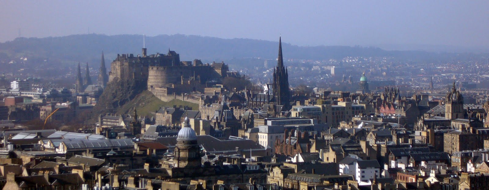
2 March - Edinburgh. Some photos.


Note to Robert: double click on the above picture of Calton Hill and you will see the one o'clock ball resting at the foot of the flagpole.
Wednesday, 2 March 2011
Sloe Gin tasting
Sloe Gin tasting night has been set for the 23rd March at 7.30p.m. in Ronnie's house. Ronnie has agreed to this but needs to consult the body of the kirk with regard to the provision of curries for the evening. (a carry in is his suggestion) The details to be ironed out in the next few weeks.
Tuesday, 1 March 2011
23 February Troon to Dundonald – The Smuggler’s Trail
Allan, Davie, Ian, Jimmy, Johnny, Paul, Rex & Robert
Another damp and dreich Wednesday – it seems to be the norm for this year – saw another postponement, this time our trip to the Luss Hills. The weatherman said there might be a window of dry for a few hours in the southwest so when we gathered in Ian’s in Killie, a local alternative was sought. Some suggested Killie to Fenwick; another put forward another Irvine valley day; but we eventually settle on Paul’s suggestion of Troon to Dundonald, a walk that was new to most. And we kept our fingers crossed for this window of dry.
As we drove the few miles to Troon we thought that we were in for another soaking for a heavy downpour hit somewhere west of Kilmarnock and threatened to stay for a while. But it was shorter lived than it first seemed and it had gone by the time we drew up in the car park at the south end of the south esplanade in Troon.
Now, the writer’s sense of geography is pretty good and he can normally tell the juxtaposition of different towns in Ayrshire. Surely Dundonald is north-east of Troon. So why should Paul and Ian direct us southward along the beach towards Prestwick? They did though, and seemed confident enough about it so we followed their direction walking along the hard sand taking care to avoid the long drifts of wet, slippery seaweed. But we weren’t on the beach too long before the leaders had us off the sand and on to the Royal Troon golf course crossing this by a footpath.
It was on the golf course that Rex was recognised by one of the golfers preparing for another shot. ‘I thought you were a mountain man, Rex’. Rex explained that sense prevails in the Ooters now and that this was an alternative to a soaking on the hill. We’re not too sure whether this explanation satisfied the inquirer but we didn’t care, we pushed on before any more comment could be made. The footpath took us over the railway by a footbridge and through a wee wood, across the Southwood Road, through the Southwood, by Lochgreen House and on to Crosbie Church.
Crosbie Church is a roofless ruin now and only the standing walls and the wee graveyard surrounding them. The present walls were built in 1681 to replace an older one of the mid thirteenth century. They have stood as a ruin since the roof blew off the church in 1759 when it was abandoned. Had we known it at the time there are one or two interesting gravestones in the old graveyard (see en.wikipedia.org/.../Crosbie_Castle_and_the_Fullarton_estate). But we didn’t know this and though we did spend a few minutes in the churchyard while speculation was made and photographs were taken, photos of the church and the masses of snowdrops growing amongst the graves, we never did find these stones.
Leaving the church, we took to tarmac along quiet lane towards Fullarton, a lane designated ‘Smuggler’s Trail’. Now we were heading for Dundonald. We had seen snowdrops last week at Durisdeer and again today at Crosbie Church but they were as nothing compared with the sight in Fullarton wood. Snowdrops upon snowdrops upon snowdrops in great clumps and drifts covered the floor of the wood until most of it was white. And the white carpet extended to a few hundred square metres. The cameramen were at it again. We look forward to seeing the results. While the cameramen had done their stuff the rest of us had walked the few hundred metres to where once stood Fullarton House (see the above web site) and, since it was now approaching eleven, we found a picnic table for coffee and let the camera boys catch up.
The main road onto which the path from Fullarton decanted us and along which The Smugglers Trail sign pointed us, was busy but at least there was a pavement for us to walk on. We kept to the pavement through Loans and beyond before we came to another sign that pointed us along a narrower road and over the even busier A77 by a bridge.
This was the road for Collenan and the old Troon reservoir. The reservoir, instead of supply Troon with water, is now the base for Troon Angling Club which stocks it annually and fly-fish it. Nobody fished it on this dreich Wednesday. Yet, as we walked across the dam, a quick glance seaward showed the sky brightening. And was that a blink of sunshine that lit the water? Would our few hours window of dry be blessed by some sunshine as well? We could only hope. Not that we would see any sunshine anyway for we were now approaching Aught Wood.
Now, as we entered the wood, we felt for the first time that we might be following the smugglers on the trail. Tradition has it that this was the route through the wood by which the goods smuggled from the Isle of Man found their way from the safe landing beaches of Troon and Barrassie to Dundonald and the rest of Ayrshire (Read John Gault’s ‘Annals of the Parish’). On this section of the trail you can almost feel the presence of these eighteenth century ‘gentlemen of the night’.
But we didn’t complete the trail to Dundonald. Paul had us climb a dirt pad, a dirt pad that brought us to the top of Hillhouse Quarry. What a pockmark on the face of the earth this is; no doubt a necessary pockmark but a grey and unsightly one from where we stood. It was Ian who spotted the fox, a spot of rusty red, the only colour on the grey floor of the quarry. As we watched, the fox ran away along a grey road until it all but disappeared in the distance, the act of which lent some true scale to the excavation of the quarry. And it was nearly gone before Rex could spot it. Poor old soul – should’ve gone to Specsavers.
We came off the lip of the quarry and found a track to old Auchens House (en.wikipedia.org/wiki/Auchans_Castle,_Ayrshire). It was to Achens that James Boswell brought Doctor Johnson from Auchinleck to visit the aged Lady Susanna Montgomery, dowager countess of Eglinton after their sojourn to the Western Isles.
Auchens is only a short hop from Dundonald and we found ourselves entering the village around lunch time. The best place for lunch was thought to be Dundonald Castle perched on its mound above the village. So we climbed the hill, found a place out of the breeze and sat down for lunch. What a magnificent place this is for a castle. The views into north and central Ayrshire are extensive, ranging from Blacksidend in the south-east through the Irvine Valley and Loudoun Hill, over the Fenwick and Stewarton Moors to the low-lying plains around Irvine. It is the perfect place for a seat of governance, both to see over and be seen from most Cunninghamme.
How the righteous are blessed. This was a remarkably good walk considering what we expected of the weather and it has given some of us new territory.
After lunch - Paul remembered his today - we came down off the hill to find a bus stop for we were not to walk back to Troon but to ride (Aren’t bus passes wonderful). Half-way back to Troon on the bus, the heavens opened. We had been lucky enough on the walk to get a window of dry now it looked as though that window was about to shut. When the bus dropped us in central Troon the rain was still coming down, and we had still a mile or so to walk back to the cars. Bugger! We got wet.
Still, a quick change of gear and a seat by the fire in The Anchorage for FRT soon restored our spirits.
Subscribe to:
Comments (Atom)