Thursday 28 November 2013

Some pictures from Maidens to Dunure Walk

Johnny contemplates his sandwiches at our coffee stop on the terrace at Culzean Castle


This is the section of beach to the north of Culzean castle along which we walked toward the sunshine.

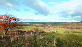
The group was well spread out on the high ground between Croy and Dunure.

Andy strides out over the new bridge over Drumshang Burn
OK, so this wasn't taken on yesterday's walk but it was taken this month - on the 10th to be exact.


Alan, Allan, Andy, Davie C, Davie Mc, Gus, Jimmy, Johnny, Peter, Rex, Robert

This walk is part of the Ayrshire Coastal Path and has oft been described before on the blog so suffice it to say that the route from Maidens was along the shore until the path up to Culzean Country Park. Walking through the park past the Swan Pond we quickly reached the castle where coffee was taken. Descending to the beach we continued past Croy until lunch was taken at the rocks adjacent to the ascent up to the cliff face. From here we followed the path until Dunure was reached.
As the pictures show, we were fortunate yet again with the weather and enjoyed the banter in the Anchorage Bar of the Dunure Inn.
For the record, this walk lasted a tad over 3 hours. Last week’s has been calculated at 22km, the best part of 14 miles in old money!

Thursday 21 November 2013

Irvine Valley Walk

Starting off near Crookedholm

A rest by the riverside (Actually waiting for the slowcoaches to catchup.)
Robert leads the way along the riverside.

Loudoun Kirk

Let us Pray. Grace before lunch?

In the Burn Anne Wood

Climbing up the valley side near Threepwood

Leaving our lunch stop on the lip of the Irvine Valley


The Darvel 'mast' on the Ga'ston Muir


Alan, Allan, Davie C, Davie Mc, Gus, Jimmy, Johnny, Malcolm, Rex, Robert

Most of us met at the Bowling Club in Hurlford where we awaited the country cousins. They, however, parked on the road and anxiously awaited the arrival of the rest of us. You couldn’t write the script, well you could but no-one would believe it!
Nonetheless, sanity prevailed, we found each other, and we were on our way on the Grougar Walk following the River Irvine. Most of this was thankfully on tarmac as the off road part suffered from the previous night’s rain i.e. it was muddy. The weather today was to be bright and reasonably warm in the shelter but, when exposed to the snell wind, it was decidedly Baltic.
We passed by Ladyton Loch and coffee was taken at our usual stop at Loudoun Kirk before crossing the A71 into Galston. Now, some of the company, names are not needed, but can be guessed, hoped and assumed that we would take the low, shorter route along the river up to Darvel, but our leader for the day, when will we ever learn?, decided that we would take the high road and head up towards the Burn Anne (or Burnawn) Walk. Through Burnhouse Wood we went and across to Cessnock Wood before emerging at our normal lunch spot. The benches here had deteriorated and were not fit for purpose so someone was heard to say there was a wee spot round the next corner. Now, have we not heard this before?
We continued on the Burn Anne Walk up to its highest point near Threepwood where lunch was taken. Allan eventually arrived extolling the virtues of this more scenic, hilly route!
It was too exposed to wait long here so we made our way to the road and turned left up past Cairnhill before turning off left again and making our way through the plantation and up to the Gallow Hill road. Here we turned right and headed up towards Eastfield where we turned left and headed down towards Lanfine Estate, taking a few minutes to observe the wild boars. The Black Bull in Darvel was a very welcome sight indeed.
This had been a long walk, five and a quarter hours, and the bodies were weary when we eventually arrived back at Hurlford (by bus of course).

For more information on the route google ‘Irvine Valley Walks’ and choose ‘Ayrshire Paths – Walking from Hurlford to Darvel’. There is also a description of the Burn Anne Walk available.

Thursday 14 November 2013

Browncarrick Hill 13 November


Allan, Davie C, Davie Mc, Gus, Jimmy, Johnny, Paul, Peter, Rex, Robert

Having met at the car park at Doonfoot close to Greenan Castle, we did not delay as the weather forecast for early afternoon was poor. Johnny was welcomed back into the fold as we walked along the beach and made our way up through Craig Tara (still referred to as Butlin’s by the Ooters)) and on to the main road for the trek past the Farm Park up to the cut off for the Carrick Hills.
Before the main ascent of the day (sounds impressive!), Allan, Jimmy and Johnny decided that they would give the hill a miss and head back to the cars, leaving the magnificent seven to continue up to the masts. Here, Peter, or rather Peter’s feet, decided enough was enough and he turned back downhill with the others proceeding up to the trig point on Browncarrick Hill before beating a hasty retreat out of the wind back to the shelter of the radar buildings for a spot of lunch. All were reunited by 1.30pm and the assembled company made its way to Rex’s for our now, annual, pool competition.
Much to his chagrin, the bookie’s favourite, Robert, went out in the first round in exactly the same way as last year i.e. potting the black only to see the white being sunk as well. After some keen competition the final was contested by Davie C and Allan. Davie was a worthy winner and stepped up to the podium to collect his trophies and to allow his supporters to see him above the table.
Thanks also to Davie for procuring the refreshments and to Rex for acquiring the pies and being a very welcoming mine host. Thanks guys!

Thursday 7 November 2013

Whitelees to Waterside 6th Nov.

Participants- Allan, Malcolm, David C, Alan, Robert, Peter, Jimmy, Rex and Paul.

Met at the usual place in Waterside without any complaints from irate residents. Transported to Whitelees visitors' centre for morning coffee courtesy of the kitty. Waterproofs donned before starting off as the forecast was poor. We walked around Lochgoin to the spine road close to the covenanter's monument. The route from here is best described using the wind turbine numbers. Follow the spine road to turbine 6, turn right shortly afterwards towards turbine 209 and then turn right again to turbines 210, 211 and 212. This route avoids the boggy stretch behind Lochgoin farm and Craigandunton reservoir. Lunch was consumed below 212. We then continued to 213 and turned left to get back to our normal route, i.e. Kiwi Lodge road and eventually Waterside. F.R.T. was taken in the King's Arms, Fenwick. The beer and chips went down well.